With more and more damaged timber and climate-related softened soils, timber harvesting and timber transportation with heavy machinery and vehicles are putting increasing strain on forest roads. In order to optimize the effort required for maintenance, a research team from the TU Ilmenau has developed an optically based system for recording the condition of forest roads in the Contura project together with the Erfurt University of Applied Sciences and five practice partners. The multimodal 3D camera system makes it possible to objectively assess the condition of forest paths using sensor-based inspection data in order to enable resource-saving maintenance.
Research
International Day of Forests: Camera system helps to maintain forest paths in a resource-saving manner
Forest roads provide access to our forests. In order for the forest roads to be used in accordance with the principles of sustainable forestry, they must be maintained. However, maintaining forest roads is expensive and has become much more complex in view of the increased volume of damaged timber in recent years. The damage caused to spruce trees in the Thuringian forest by the bark beetle alone is higher than ever before: according to the state forestry office, around six million solid cubic meters of damaged wood were produced last year. To prevent the pests from spreading to healthy trees, the infested trees must be felled as quickly as possible and the wood removed.
"The best time for harvesting and transporting raw timber is usually winter, when the forest floors are frozen and the forest roads are particularly stable, which means they can withstand both forestry machinery and timber transport trucks designed for public road traffic conditions," explains Prof. Notni, Head of Quality Assurance and Industrial Image Processing, who is leading the Contura project at TU Ilmenau. However, due to the mild temperatures caused by the climate and the increased rainfall in winter, the forest floors and paths are often softened early on.
If you walk through the forest with your eyes open, you will see that the heavy forestry machinery often leaves deep tracks on the forest paths.
Such damage, but also uncontrolled vegetation or other localized damage, can make it difficult or even impossible to use the paths - whether for transporting timber, for walks or for emergency vehicles.
"Unlike damage to highways, for example, there has not yet been an economically viable system that records such damage to forest roads in a kind of digital map," says Notni. As part of a joint project together with the Erfurt University of Applied Sciences and five partners, the TU Ilmenau has now developed such a system, which forestry companies can use to automatically record the condition of the path body, ditch area and clearance in the forest and derive measures and costs for maintaining the paths.
Digital depth maps of the forest paths
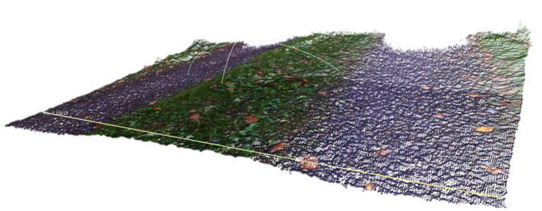
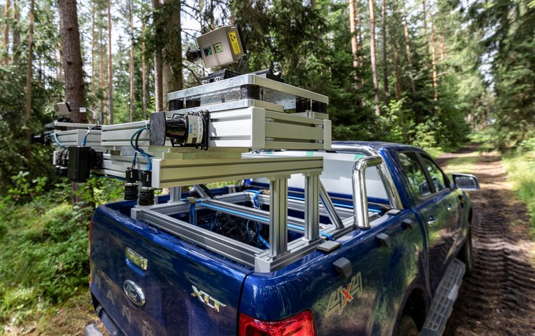
The complex multimodal 3D sensor system developed as part of the Contura project at Ilmenau Technical University consists of several stereo cameras and so-called time-of-flight cameras (ToF), which are mounted on a vehicle and measure the distance to the objects based on light pulses. They are combined with high-resolution color cameras. In this way, a wide variety of features of the forest paths and their surroundings can be recorded in 3D as the vehicle drives through the forest, stored in a data set and depth maps of the forest paths created: "In addition to the condition of the road itself, the system can also record the width of the forest edge, the condition of the ditches at the edge of the path that drain the water, the embankments and the space above the path that must be kept clear of vegetation, for example, and make it available as a digital twin," explains Prof. Notni:
That means we can see: How deep are the ruts in the forest paths? Is there any interfering vegetation? For example, are there branches protruding into the path that need to be cut away, or are there log remains in the trench?
With the help of adaptive software (AI) developed by HD Vision GmbH, the data and damage recorded in this way can then be evaluated and assigned to damage classes. "This enables forest owners and forestry companies to better plan and calculate the necessary maintenance measures and their costs and to initiate cost-cutting measures at an early stage," explains TU Ilmenau project coordinator Raik Illmann: "At the same time, the captured 3D data is highly compressed and thus allows a quick web-based display."
Additional sensors for fluctuating light conditions
However, the development of the system was initially associated with a number of challenges, according to Prof. Notni:
Under constant conditions, such sensors can be easily synchronized with each other. However, it is not only inadvertently recorded vegetation that can distort the profile of the path.
The 3D sensors also had to be attached to the vehicle in a particularly stable manner and calibrated due to the uneven paths: "If, for example, the viewing direction was no longer correct due to the fluctuations, we had to discard the image data. We also had to take into account the different lighting conditions: Sometimes you're in the shade, sometimes in the sun. This is very challenging for an image capture." The scientists solved this challenge by installing additional photometric sensors for the stereo image capture, which measure the brightness in front of the vehicle while driving so that the camera's exposure times can be adjusted accordingly.
Follow-up project planned to determine the vegetation along the roadside
The scientists at the Group for Quality Assurance and Industrial Image Processing are currently looking into the extent to which the findings can also be transferred to cycle paths and special rural paths. In a follow-up project on biodiversity, they also want to work with the Data-intensive Systems and Visualization Group (dAI.SY) to develop a system for determining the vegetation at the edge of paths in order to make a contribution to nature conservation.
Our aim is to provide the forestry industry with information about what exactly is growing along the edge of the path and which areas of the path may need to be treated with particular sensitivity because they contain plants worthy of protection.
„Forests and Innovation: New Solutions for a Better World“: About International Day of Forests on 21 March In order to draw attention to how important it is for us humans and the environment to manage forests sustainably and make the best possible use of their resources, the United Nations General Assembly proclaimed 21 March the International Day of Forests in 2012. The Day celebrates and raises awareness of the importance of all types of forests. In 2024, the theme of the day is „Forests and Innovation: New Solutions for a Better World“. |
The Contura project is funded by the Federal Ministry of Food and Agriculture (BMEL) via the Agency for Renewable Resources (FNR).
Prof. Gunther Notni
Head of Quality Assurance and Industrial Image Processing