European cities are experiencing more and more extreme heatwaves and their air is becoming increasingly polluted - with noticeable consequences for health and quality of life. Together with 17 European partners, Jana de Wiljes, Professor of Mathematics in Data Science at TU Ilmenau, is developing models that better map heat and air pollution and test measures for better urban climates, from more urban greenery to reducing emissions. We spoke to her about her research.
Prof. de Wiljes, record temperatures were measured in Europe in 2024, prompting cities such as London and Milan to introduce emergency measures to combat dangerously high levels of air pollution. The UrbanAIR project aims to support cities in planning measures for better air quality and more heat protection in a targeted and precise manner. What motivated you to get involved in this project?
My main motivation was the urgent need for research that deals with the actual and increasing effects of climate change and at the same time develops approaches to better deal with its consequences. At the same time, I think it is important to continue to raise awareness of what concrete climate impact scenarios could look like, especially in cities.
I was also particularly inspired by the opportunity to work with an extraordinary and truly interdisciplinary consortium of scientists from all over Europe, coordinated by Delft University of Technology. Being part of a project led by Prof. Dr. Femke Vossepoel, whom I greatly respect both academically and personally, and working together with experts from many complementary fields makes UrbanAIR unique for me.

To what extent can the digital models that you are developing help us to better understand the consequences of climate change and design cooler, cleaner and more climate-resilient cities?
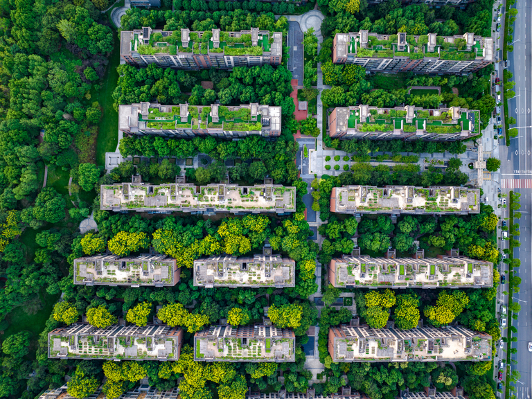
Together with various cities, including Barcelona and Antwerp, but also Paris, Rotterdam and Bristol, and in some cases also with the respective city administrations, we are taking a closer look at individual cities and calculating high-resolution simulations for these specific urban environments. This gives us a much better understanding of how heat develops in cities, for example, how it is distributed spatially and how long it is stored there. Urban materials such as concrete or asphalt store heat particularly efficiently and release it again with a time delay, which contributes to the so-called urban heat island effect.
Within these simulations, various realistic adaptation measures can then be tested, such as increased greening with trees, the creation of wind corridors or even light-colored or white-painted roofs and facades, as is often seen in more southerly countries. Trees can contribute to cooling through shade and evaporative cooling, while wind corridors can improve air exchange and transport warm air out of the city more quickly. In turn, bright surfaces reflect more of the sun's rays, also known as higher albedo, preventing buildings and streets from heating up so much.
In this way, it is possible to investigate how strongly such measures influence the intensity and perception of heat waves in cities and under which conditions they are particularly effective.
How can these models and technologies you are developing be understood in practical terms?
Simulations that model the heat development in a specific city, for example, taking into account the respective blocks of houses and in special cases even individual trees, can be understood as a kind of digital twin of the city. The climatic and meteorological processes that drive or influence these developments serve as a kind of "forcing" that we can feed into the computer-modeled twin with the help of current data.
If this so-called digital twin depicts the processes of reality relevant to us with sufficient accuracy, changes can first be tested virtually before actual interventions are made in the urban environment. So instead of immediately redesigning the real city, the digital twin can first be used to test whether a certain measure leads to a positive development.
To what extent can these models also help to better assess future developments?
In fact, scenarios that have not yet occurred can also be examined in this way. Even if a city is not currently affected by long, regular periods of heat, the meteorological conditions can be specifically changed within the digital twin. This allows us to simulate future extreme events in order to better understand how a particular city would react under extreme climatic conditions.
Urban environmental processes are extremely complex: buildings, traffic, weather, and human behavior all interact. What challenges does this pose for the modeling of such systems?
The biggest challenge is that realistic modeling requires enormous amounts of computing time. There are already huge supercomputers behind modern weather forecasts, which often have a much lower resolution than the models we want to develop for urban areas. Nevertheless, even in this case it is extremely difficult to describe uncertainties comprehensively in mathematical terms, as this would require a large number of simulations that are often not feasible in practice.
In addition, cities are characterized by a multitude of interlinked processes. Buildings influence air currents and temperature distributions, traffic changes emissions and heat generation, and human behavior also has an impact on the urban climate. Realistically mapping these interactions represents an enormous mathematical and technical challenge.
How do you address these challenges?
By approaching the modeling of an entire city step by step. We start by examining smaller sections or individual parts of the city in order to develop and test methods there before gradually expanding the models.
Surrogate models also play an important role here. Once trained, these surrogate models require significantly less computing time than the original physical models. Artificial intelligence methods are often used for this. However, even this remains challenging, as such models can usually only approximate the full dynamics and complexity of the underlying original model.
Looking ahead, what role could such mathematically driven models play in other fields in the future?
From a mathematical point of view, the methods used are relevant for a wide range of applications. Whenever real measurement data is combined with models, which are often based on physical, biological or other scientific principles, these methods can be used.
Among other things, this involves determining uncertainties in the results, particularly in the extreme range, or developing optimal strategies for positive changes. It is precisely these questions that describe many of the major challenges facing our society today.
One example is medicine, where we are trying to make therapies as individualized and effective as possible. To a certain extent, this requires a digital twin of the patient that reflects the characteristics and processes of this individual person as realistically as possible.
At the same time, the progress we make in this project, be it through the refinement of existing algorithms or through new theoretical insights into these kinds of challenges, has the potential to benefit a wide range of other application areas.
About the UrbanAIR project
The UrbanAIR project - URBAN simulation for AIr quality and heat Resilience strategies - coordinated by Delft University of Technology, brings together leading experts from research, industry and politics. In addition to Delft University of Technology and TU Ilmenau, the participating institutions include the Barcelona Supercomputer Center, Future Needs Management Consulting Ltd, Nicosia, the Imperial College of Science, Technology and Medicine, London, the Norwegian Research Center, Bergen, Ove Arup & Partners Ireland Limited, Dublin, the Royal Netherlands Meteorological Institute, De Bilt, the Stichting Global Resilient Cities Network, Rotterdam, the Swedish Meteorological and Hydrological Institute, Norrkoeping, the University of Toulouse III - Paul Sabatier, the University of Freiburg and the University of Hanover.
The project has a total budget of 14.3 million euros and will run for four years. It is funded under the call "§HORIZON-INFRA-2024-TECH-01-03: New Digital Twins for Destination Earth" and directly supports European strategies for climate adaptation, urban sustainability and public health.
"Funded by the European Union. Views and opinions expressed are however those of the author(s) only and do not necessarily reflect those of the European Union or European Research Executive Agency. Neither the European Union nor the granting authority can be held responsible for them."
Contact
Prof. Jana de Wiljes
Fachgebietsleiterin Mathematics of Data Science